
Mullach Clach a' Bhlair
Munro summit on the Moine Mhor above Glen Feshie
The Moine Mhor is the vast undulating grassy upland between Glen Feshie and the Lairig Ghru, with Mullach Clach a'Bhair being the highest point at the south-west corner.Mullach Clach a' Bhlair
| Height | 1019m |
| Prominence | 104m |
| Meaning | peak of the stone of the plain |
| Lists | Munro, 114 |
| Location | East of Glen Feshie, Cairngorms and North East Grampians |
| Grid Ref | NN883927 |
| Lat/Lon | 57.01174, -3.84069 |
The western edges the vast Cairngorm plateaux are dominated by the undulating and lochan-pitted Moine Mhor moorland and at the southern end of this is Mullach Clach a'Bhlair. Being fairly featureless, it is only the height above sea-level which gives this hill Munro status.
The easiest approaches are from forested Glen Feshie, where a network of fine tracks and paths lead through Caledonian woods and up heather-clad slopes onto the Moine Mor plateau. In the upper reaches of Glen Feshie and at the western foot of Mullach Clach a'Bhlair is Ruigh Aiteachain bothy, handy for a back-packing stay in the area. Navigation on the undulating high ground surrounding Mullach Clach a'Bhlair away from track will be challenging in mist or white-out !
Routes up Mullach Clach a' Bhlair
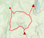
Sgor Gaoith and Mullach Clach a'Bhlair from Glen Feshie | |
|
Above Glen Feshie, Sgor Gaoith and Mullach Clach a'Bhlair are two Munros that lie in the heart of Rothiemurchus, a vast area of Caledonian forest, lochs, rivers, glens, mountains, and wild landscapes. The high ground, known as the Moine Mhor, is fairly featureless for the most part, but fortunately some good paths and tracks aid navigation. Peaks : 2 Munros
Ascent : 1100m (3610ft) Distance : 26km (16m) Time : 8:20hr |


")


