

Stob a' Choire Odhair and Stob Ghabhar
Hillwalking route over the Black Mount's southern Munros
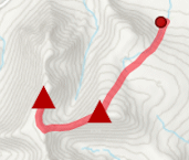
Circular hillwalking route from Victoria Bridge over Stob a' Choire Odhair and Stob Ghabhar in the Black Mount returning down aside some spectacular waterfalls.
Route outline
| Munros | ||||
| Ascent | 1250m (4100ft) | |||
| Distance | 15km (9m) | |||
| Time | 5:50hr | |||
| Start/finish | Victoria Bridge Grid Ref : NN270423 | |||
| Terrain |
| |||
| Nav |
| |||
| Effort |
| |||
| Scenery |
| |||


Stob a'Choire Odhair and Stob Ghabhar are the two Munros that command the view above the shores of Loch Tulla when driving along the A82 north of Bridge of Orchy. These predominantly grass covered hills have narrow ridges and dark corries hidden from roadside view.
Taken together, the summits form a wonderful circular route that begins on fine estate tracks heading in from Victoria Bridge at the end of the public road by the western end of Loch Tulla.
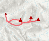
Show map
Route description
1. Getting to Victoria Bridge

Walking in from Victoria Bridge and nearing Clashgour Hut
On the A82, 10km north of Tyndrum is Bridge of Orchy, with the hotel sitting on the west side of the road.
Immediately past the hotel, there is a narrow, single-track road heading over the River Orchy and north towards Loch Tulla. Follow this road, past the Inveroran Hotel, to just before its end at Victoria Bridge, where there is a car-park for around 20 vehicles.
2. Stob a'Choire Odhair

Hiking up Stob a'Choire Odhair with Ben Cruachan behind
Leave the car-park via the wet path behind the information board and head to Victoria Bridge. Cross the bridge, then take the left fork at the junction  .
.
Now on a good track, follow it for 1.5km to a green hut  - this was an old school house, but is now Glasgow University Mountaineering Club hut.
A stalker's path heads north from here - follow it up for 2km to where a burn  descends over the track (and in spate can obstruct progress).
Cross the burn, then turn right onto a path that aims directly uphill through the heather. The path twists and turns climbing and eventually disappears into stones and boulders higher up - by which time you should be able to see Stob a'Choire Odhair's summit. The untidy cairn on the summt  is large enough to shelter out of the wind and fine views are to be had over the Black Mount and beyond
3. Stob Ghabhar

Aiming to the bealach below Aonach Eagach
From Stob a'Choire Odhair's summit, turn west-south-west and head over pathless ground for a bit. A path gradually forms, and follow it downhill, with no difficulties, towards the bealach  between Stob a'Choire Odhair and Stob Ghabhar (there is an escape route heading directly down from here into Coire Toaig to pick up a track and return back to the burn crossing ).
Staying on a path, cross the bealach, then start gaining height as you turn south-west. The path disintegrates into several fainter routes up the scree. Choose any one, but regardless of which one you choose, guaranteed you'll be clamering up loose rock.
The grass covered east end of the Anoach Eagach is reached, turn west and follow the faint path.
Further on the crest narrows to a notched ridge  and some entertaining easy scrambling is to be enjoyed as progress is made.
The ground widens and drops slightly to a bealach, where a thick iron post  marks the start of a line of fence posts.
On a path, follow the posts to Stob Ghabhar's summit perched  above Coirein Lochain. Superb views in all directions
4. Direct return via waterfalls

Waterfall on the way down from Stob Ghabhar
From Stob Ghabhar's summit, retrace your steps downhill to the thick iron post above Coirein Lochain. Instead of continuing back over the Aonach Eagach, look slightly right at the post and a path can bee seen aside a line of fence posts heading south-east.
Follow this faint path initially over bouldery ground on Stob Gabhar's south-east shoulder around Coire na Muic. Gradually the boulders and stones are replaced by wet grass lower down, and the path begins to turn westwards to approach Creag an Steallaire  .
.
Keeping to the path on the southern bank of the Allt Coire na Muic, the ground begins to steepen and some care is needed.As you descend, there are a couple of pools below waterfalls - excellent for skinny-dipping on a hot day !
The path zig-zags down, around the waterfalls, then reaches the Allt Toaig  , which is crossed to rejoin the track to follow back to Clashgour Hut and return to Victoria Bridge. If the Allt Toaig is in spate, it may be impossible to cross, in which case keep to the west bank and follow faint trods southwards to Clashgour Hut.
5. Return over Sron a' Ghearrain

Sron a' Ghearrain from Stob Ghabhar
From Stob Ghabhar's summit, follow the line of fence-posts north-west wards on the crest of the mountain's west shoulder. There is a faint path to trace to drop to a bealach before a slight climb up Sron a' Ghearrain  - Stob Ghabhar's western Munro-Top.
Leaving the small cairn on this summit behind, aim south-west following the edge above Coire Ghabhar. The edge curves and at around c900m, leave it and head directly downhill bounding over grass (watch out for hidden boulders).
At around c650m, you should meet up with a stalker's track  - follow this down to the Allt Ghabhar and into forestry - it gets a bit mucky from here ! Nearing Clashgour farm, the track crosses the burn via a footbridge
  , from where follow the farm track close to the farm
  , then southwards to meet up with more forestry
  . The track now very mucky in bits, travels down toward to the Abhainn Shira, where a large gate
  in a deer fence needs negotiated (it was locked when I was there). A worn path then keeps to the northern bank of the Abhainn Shira and meets up with the track around 200m before Clashgour Hut .
Route profile »

Maps and GPX downloads »


|
Download GPX of route |
The map images above link to items on Amazon. A small commission is earned on any map purchased which helps fund the operating costs of this website.
Weather forecasts »
| Regional | MWIS - Western Highlands |
| Peak specific | Mountain Forecast.com Met Office YR.no |
| Seasonal | SAIS - Glencoe Midge forecast |
Alternative and nearby routes »
Black Mount mountains from Glen Etive | |
|
A there-and-back hillwalking route from Glen Etive up rough terrain to the Corbett peak Beinn Mhic Chasgaig and over to the Munros Creise and Meall a' Bhuiridh. Peaks : 2 Munros
Ascent : 1500m (4920ft) Distance : 15km (9m) Time : 6:15hr |
Meall a' Bhuiridh and Creise | |
|
A there-and-back hillwalking route from Glencoe Ski Resort up Meall a' Bhuiridh and Creise, the two northern Munros of the Black Mount. Peaks : 2 Munros
Ascent : 1090m (3580ft) Distance : 10km (6m) Time : 4:20hr |
Black Mount mountains from Glen Etive | |
|
|
A there-and-back hillwalking route from Glen Etive up rough terrain to the Corbett peak Beinn Mhic Chasgaig and over to the Munros Creise and Meall a' Bhuiridh. Peaks : 2 Munros
Ascent : 1500m (4920ft) Distance : 15km (9m) Time : 6:15hr |
Shepherds of Etive | |

|
The rugged mountains and iconic peaks of Buachaille Etive Mor and Etive Beag guard the entrances to Glencoe. Long high-level ridges between Munro summits and some easy scrambing make for a classic hillwalking route. Peaks : 4 Munros
Ascent : 1875m (6150ft) Distance : 19km (12m) Time : 8hr |


