
Cairngorm 4000s
Circular hillwalking route over the Cairngorm 4000ers from Glenmore, including Ben Macdui, Braeriach, Cairn Toul, Sgòr an Lochain Uaine and Cairn Gorm.
Route outline
| Munros | ||||
| Ascent | 2250m (7380ft) | |||
| Distance | 28km (18m) | |||
| Time | 10:45hr | |||
| Start | Cairngorm Mountain car-park Grid Ref : NH990059 | |||
| Finish | Sugar Bowl car-park Grid Ref : NH985073 | |||
| Terrain |
| |||
| Nav |
| |||
| Effort |
| |||
| Scenery |
| |||


Terrain varies over the route, heather lower down leading to grass higher up and onto arctic-like tundra on the plateaux. A fair amount of the route is on paths, though when away from paths, good navigation skills will be needed. Some of the route follows the rims of coires above huge drops down to hiddens lochans, beware cornices can extend well beyond the edges in winter.
Starting at a height above 600m, there's less ascent than expected, with the descent down Ben Macdui into the Làirig Ghrù and Glen Dee followed by the climb up Cairn Toul being the most demanding part of the route. A good option for hillwalkers is to back-pack this route over 2 days, overnighting in Glen Dee.
Fellrunning will get these Munros bagged in one day. If you fancy having a go at beating the record around the Cairngorm 4000s, it currently stands at under 4 hours and it starts and finishes from Glenmore Lodge. Details are on the Scottish Hillrunners website.
Show map
Route description
1. Getting to Cairngorm Mountain car-park

Cairngorm from the Day Lodge
On the south side of Aviemore, there is a roundabout, from where the road to Glenmore and Cairngorm Mountain begins. It's a journey of around 15km passing lovely Loch Morlich on the way.
There is a frequent bus service from Aviemore direct to Cairngorm Day Lodge.
To park in the Cairngorm Day Lodge car-park costs from £3 outwith the winter snowsports season.
During the winter snowsports season parking is free, however it may be very busy or even full, in which case parking in the lower Coire Ciste car-park is recommended - from where an approach to Cairngorm is made via Cnap Coire na Spreidhe.
2. Cairngorm

Windy Ridge path with Cairngorm behind
From the large car-park head up on the track between the Day Lodge and Base Station. Immediately after passing under the funicular railway, take the path off left at where a sign points to the "Windy Ridge Path".
The path is well constructed and is quite steep to begin with, initially twisting and turning as it climbs aside the Day Lodge Piste.
The path turns eastwards away from the piste, with the incline easing a little. Higher up it crosses through a wooden snow-fence and over the M2 ski run while gradually turning southwards as it climbs Sròn an Aonaich.
Crossing back over the ski pistes, the Top Station and Ptarmigan Restaurant  are reached. Above this building, a well constructed path with a line of posts either side (linked together in summer with rope), begins the final climb towards Cairngorm's summit.

Snow bunting on Cairngorm's summit
 , where there is a large well constructed cairn with the Cairngorm Automatic Weather Station nearby.
Snow bunting on Cairngorm's summit
3. Ben Macdui

Descending Cairngorm, Cairn Lochan ahead
Leave Cairngorm's cairn and weather station and head due west over bouldery ground. A constructed path can be picked up and followed downhill, though this may not be too obvious as snow and ice take their toll on it.
The path drops down to level ground and bypasses 'Point 1141' to reach a bealach above some airy drops into Coire an t-Sneachda below.
Uphill, the path can be traced through boulders onto the 'Munro Top' of Stob Coire an t-Sneachda  , a superb spot for taking in views ! In winter, the crags and cliffs are famed for their winter climbing routes.
Continue walking south-westwards following the rim of Coire an t-Sneachda and drop to the next bealach  above Coire Domhain.
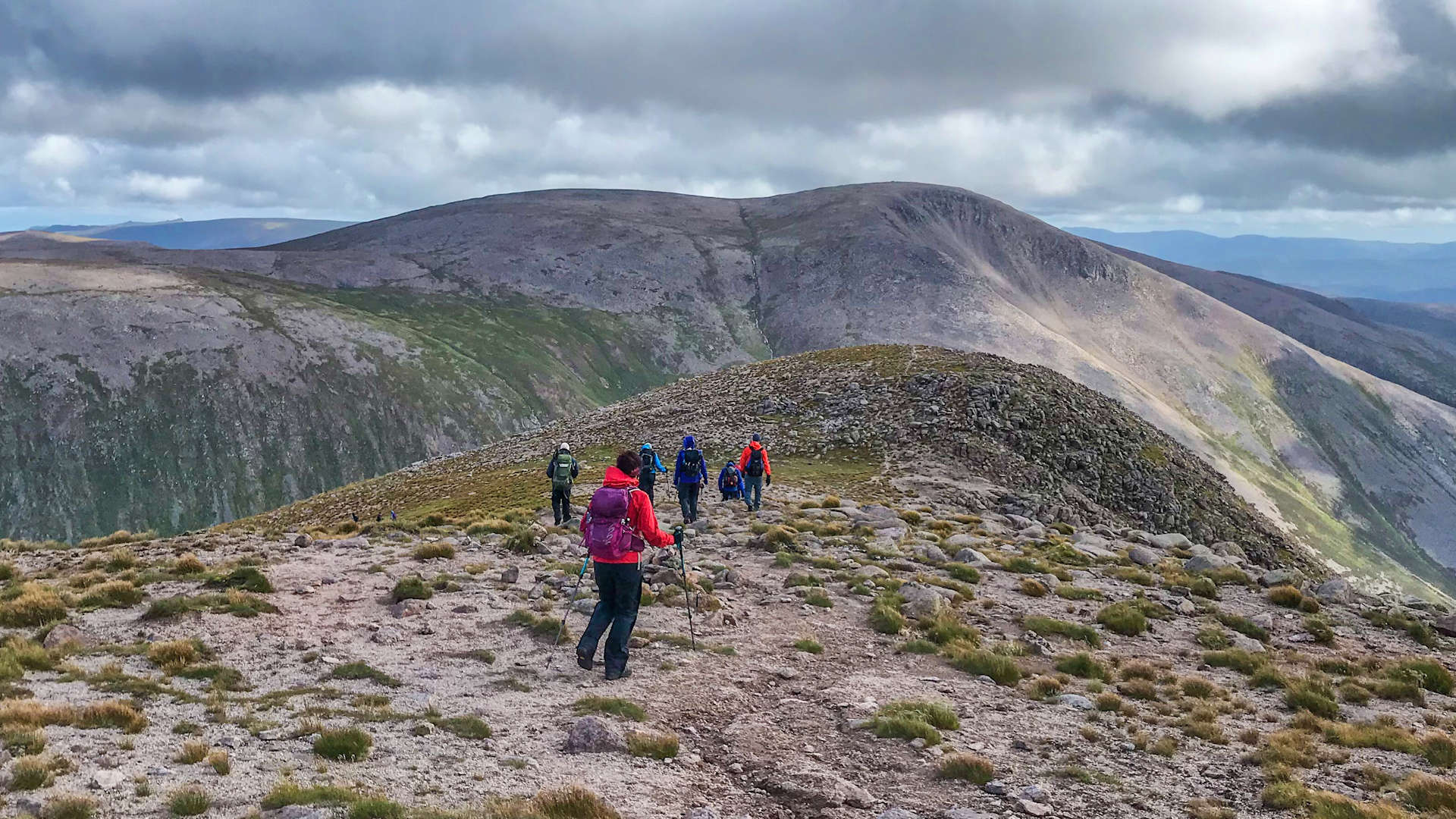
To aim for Ben Macdui, turn left onto an obvious path and follow it southwards as it cuts through a grass-covered slope. The path turns south-west and travels for a further 1km to reach Lochan Buidhe  - a fine place to stop and take in the atmosphere.
Beyond the lochan, the path turns more southwards and after another 1km, leaves the grass-covered plateau and begins to climb on more stony tundra with patches of boulderfield.
A series for cairns is met, aiding navigation on the approach to Ben Macdui, though the path is fairly clear most of the way.

Heading up Ben Macdui from Lochan Buidhe, Braeriach behind
 has a large cairn, on top of which is a trig pillar, and a viewfinder nearby. Cairn Toul and Braeriach look spectacular from Ben Macdui, though due to Ben Macdui's vast flat large summit, a short wander from the summit will be needed to get the best views.
Heading up Ben Macdui from Lochan Buidhe, Braeriach behind
4. Cairn Toul

Descending Ben Macdui, Cairn Toul ahead
The descent off Ben Macdui will test your joints and there is no right or wrong way for this. I found that heading directly off from the summit ended up in boulderfield and then deep heather doing head-plants - direct and quick down to Glen Dee  , but not the most enjoyable !
Instead, a better option would be to follow faint traces of path south-east to the top of the Allt Clach nan Taillear, then head south-west. A path can be picked up here-and-there, becoming more obvious lower down. As ground levels, the path turns to aim for Càrn a'Mhaim, you'll need to leave it and bound over heather into Glen Dee.

On the north-east ridge of Cairn Toul
- The easiest line is to head up the north ridge
 , steep at first, it becomes wide and gives a lovely views back over Lochan Uaine to Braeriach (see the West of Làirig Ghru route for more info).
 - The most direct line is the north-east ridge
 which is pretty steep but without difficulty and climbs around the northern side of Coire an t-Sadhail aiming directly for Cairn Toul's northern top (and summit).
 - There is also the south-east ridge
 , around the southern side of Coire an t-Sadhail, which involves some Grade 1 and slightly exposed scrambling on the approach to Cairn Toul's southern top.
 , the northern one marks the top.
On the north-east ridge of Cairn Toul
5. Sgòr an Lochain Uaine (Angel's Peak)

On the way to Sgòr an Lochan Uaine, looking back to Cairn Toul
From Cairn Toul's northern cairn, aim west and handrail the rim above Coire an Lochain Uaine. A path can be followed most of the way, occasionally zig-zagging to avoid some boulders, down to the bealach between Cairn Toul and Sgòr an Lochain Uaine.

Looking to Ben Macdui from Sgòr an Lochan Uaine
 (also known as The Angel's Peak), a fine viewpoint to Braeriach and Ben Macdui.
Looking to Ben Macdui from Sgòr an Lochan Uaine
6. Braeriach (Am Bràigh Riabhach)

Càrn na Criche from the south-east
Leaving Sgòr an Lochain Uaine behind, hike south-west following the edge of the crags above Garbh Coire. Terrain underfoot is annoyingly bouldery in bits, but as height is lost, becomes more relaxed. From the next bealach, start uphill on a fine path cutting a route through the loose arctic-like tundra. Càrn na Criche  is the high point of the next plateau, there's a small cairn on the summit, which can be bypassed if taking a direct route onwards.
Now on grass-covered ground, aim north-north-east for the Wells of Dee  , an extraordinary place where two burns meet, then flow over the Falls of Dee.

Summit of Braeriach
 appears abruptly, the cairn perched above massive drops of Coire Bhrochain. Views are stunning, particulary over to Cairn Toul.
Summit of Braeriach
7. Return through the Chalamain Gap

Descending Braeriach toward the Làirig Ghru
In winter, beware the cornices that can form ! Follow the rim of Coire Bhrochain north-east, then east. A path quickly forms as terrain gets easier, then leads down to the bealach below Sròn na Lairige (if you're here and need to get out of wild weather, there is an escape route directly down to the Làirig Ghrù below).
The path leads around Sròn na Lairige's summit  over a delightful grass-covered crest as it approaches the top of the crags above the Làirig Ghrù. Just when legs are starting to tire, more stony ground and boulderfield needs crossed as the descent to the Làirig Ghrù begins. The path becomes more maintained as it enters heather and does its final drop into the Làirig Ghrù
  .
.
Cross the burn in the Làirig Ghru, then steeply straight uphill on the granite steps of the path aiming to the Chalamain Gap  . The path through the gap is fine, but can be hard work in winter if banked up in snow, in which case, there is another path traversing above the crags on the north side of the gap.

On the way to the Làirig Ghru, Creag a' Chalamain ahead
On the way to the Làirig Ghru, Creag a' Chalamain ahead
Route profile »

Maps and GPX downloads »


|
Download GPX of route |

|
Open route in OS Maps |
Information on maps and GPX files is on this page.
The map images above link to items on Amazon. A small commission is earned on any map purchased which helps fund the operating costs of this website.
Weather forecasts »
| Regional | MWIS - Cairngorms and Monadhliath |
| Peak specific | Mountain Forecast.com Met Office YR.no |
| Seasonal | SAIS - Northern Cairngorms Midge forecast |
Alternative and nearby routes »
Cairngorm and Ben Macdui | |

|
Hillwalking route up Ben Macdui and Cairn Gorm with an optional relatively easy scramble on Fiacaill Ridge in good summer conditions. Peaks : 2 Munros
Ascent : 1000m (3280ft) Distance : 17km (11m) Time : 6hr |
West of Làirig Ghrù from Glenmore | |

|
Hillwalking route up Braeriach, Cairn Toul and Sgòr an Lochain Uaine, vast high plateaux west of the Làirig Ghru with superb views over the Cairngorms. Peaks : 3 Munros
Ascent : 1850m (6070ft) Distance : 28km (17m) Time : 10hr |
Cairngorm Darkside from the north | |

|
Route up Ben Macdui and Beinn Mheadhoin from Cairn Gorm ski centre, visiting Loch Avon’s beaches and the famous Shelter Stone en route. Peaks : 4 Munros
Ascent : 1730m (5680ft) Distance : 27km (17m) Time : 9:40hr |
Meall a' Bhuachaille from Glenmore | |

|
Hillwalk from Glenmore via Ryvoan and the Green Lochan to Meall a' Bhuachaille, passing Ryvoan Bothy before a direct ascent on a decent path. Peaks : 1 Corbett
Ascent : 550m (1800ft) Distance : 9km (6m) Time : 3:15hr |
Cairngorm darkside from Linn of Dee | |

|
Route up Ben Macdui and neighbouring Munros from Linn of Dee. Vast plateaux, granite tors, forests and the chance to spot reindeer herds. Peaks : 4 Munros
Ascent : 1850m (6070ft) Distance : 35km (22m) Time : 10:15hr |


