
Carn an Fhreiceadain from Kingussie
Hillwalking route up Carn an Fhreiceadain from Kingussie
The flat-topped summit of Carn an Fhreiceadain overlooks Kingussie, from where fine estate tracks head up onto the plateau making for a uncomplicated circular hillwalking route.
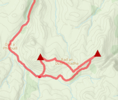
Route outline
| Corbetts | ||||
| Ascent | 680m (2230ft) | |||
| Distance | 16km (10m) | |||
| Time | 5:00hr | |||
| Start/finish | Kingussie Golf Course Grid Ref : NN755013 | |||
| Terrain |
| |||
| Nav |
| |||
| Effort |
| |||
| Scenery |
| |||


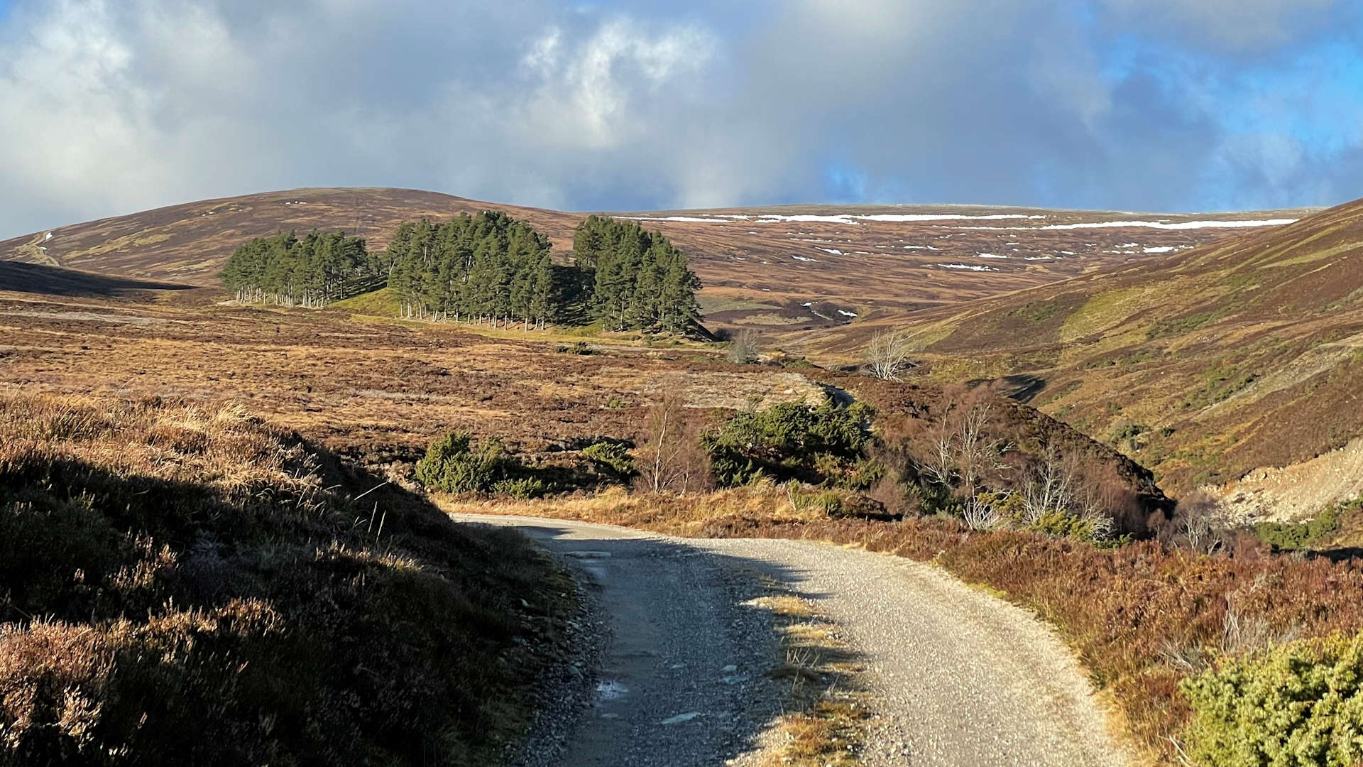
This circular route up Carn an Fhreiceadain starts from the golf course that overlooks the town of Kingussie and follows estate tracks for its length.
This well signposted route begins on tarmac for the first 2km, thereafter is on rough, but cycleable estate tracks which lead onto higher ground and to Carn an Fhreiceadain's summit. Unless covered in thick snow, navigation is undemanding following the tracks.
Show map
Route description
1. Getting to Kingussie Golf Club

Start by Kingussie Golf Course
In the heart of Kingussie, just to the west of the traffic-lights at the town's crossroads, Gynack Road heads north overlooking the west bank of the Allt Mor. Ardvone car-park is just up from the start of this road where there are also public toilets.
The hillwalking route up Carn an Fhreiceadain begins from a further 1km up Gynack Road at the entrance to Kingussie Golf Club. There is parking available here (the sign does say private parking, but there doesn't seem to be any objection to parking if the golf club isn't busy).
2. Carn an Fhreiceadain

Cairn just before Carn an Fhreiceadain
Just before the entrance to Kingussie Golf Club, there is a bridge over the Allt Mor - cross this and begin to walk up Ardbroilach Road. Pass the remaining houses of Kingussie, the road heads into Kingussie Golf Club, and travels northwards into Glen Gynack.
After around 2km walking, Pitmain Lodge  is reached, with a sign pointing to the right to Carn an Fhreiceadain. Just beyond this, another sign indicates the choice of heading up a west or east route up Carn an Fhreiceadain - I'd prefer doing a circular clockwise route, therefore heading west first.
Over a bridge, past some sheds, over another bridge and through a gate in a deer-fence, it's on to open hillside. Ignore the track signposted 'North Gynack' and keep heading uphill.
The track continues uphill for around 2km to an interesting moraine  with woodland, then drops down to cross the Allt Mor
  onto its northern bank.
The track now begins to climb more steeply and comes to a couple of junctions - keep left at the first  and right at the next
  . The track now on more gentle gradient, climbs all the way to Carn an Fhreiceadain's flat summit, just before which is a tall and well constructed rectangular cairn
  , which is now beginning to tilt. There is trig point sheltering within a dyke on the top
  and fine views are to be had from here.
3. Beinn Bhreac and return

Looking down to Beinn Bhreac from Carn an Fhreiceadain
From Carn an Fhreiceadain's trig point, continue north-east on the track towards Carn an Fhreiceadain's minor north-east summit  .
.
The descent begins with the track turning south-east and dropping to a col, before heading up a slight rise to meet up with the small cairn on Beinn Bhreac  .
.
Now heading south, the track makes for a quick an fairly uneventful descent back to the forests surrounding Pitmain, passing a small stalker's bothy  on the way.
The bridge by Pitmain Lodge is met again, beyond which simply retrace your steps back to Kingussie.
Route profile »

Maps and GPX downloads »


|
Download GPX of route |
The map images above link to items on Amazon. A small commission is earned on any map purchased which helps fund the operating costs of this website.
Weather forecasts »
| Regional | MWIS - Cairngorms and Monadhliath |
| Peak specific | Mountain Forecast.com Met Office YR.no |
| Seasonal | SAIS - Creag Meagaidh Midge forecast |
Alternative and nearby routes »
Carn na Saobhaidhe from Strathdearn | |

|
Route taking a cycle along Strathdearn to the heart of the Monadhliath wilderness, followed by a hike over moorland to Carn na Saobhaidhe above the many turbines of Corriegarth windfarm. Peaks : 1 Corbett
Ascent : 630m (2070ft) Distance : 30km (19m) Time : 3:45hr |
Geal-charn Mor and Craigellachie | |

|
Late autumn is a fine time to hike through the golden woodlands of Craigellachie Nature Reserve and up the 'Burma Road' on to the summit of Geal-charn Mor with its superb panoramic views of the Cairngorms. Peaks : 1 Corbett
Ascent : 775m (2540ft) Distance : 14km (9m) Time : 4:50hr |
Carn Dearg Mor and Meallach Mhor | |
|
From the forests surrounding Drumguish, a cycle on estate tracks through quiet Glen Tromie leads to a remote corner of the western Cairngorms, from where much hiking over heather and grass bags Carn Dearg Mor and Meallach Mhor. Peaks : 2 Corbetts
Ascent : 1040m (3410ft) Distance : 41km (25m) Time : 6:45hr |
Monadhliath Munros | |

|
The rolling landscape of the Monadh Liath is vast and feels very remote and wild. There are four Munros hiding in the expanse, all of which can be bagged in one linear route taking in A'Chailleach, Carn Sgulain and Carn Dearg in quick succession following fence-lines, then Geal Charn challenging navigation skills over featureless terrain. Peaks : 4 Munros
Ascent : 1420m (4660ft) Distance : 30km (19m) Time : 9:50hr |


