

Munros above Jock's Road
Hillwalking route on Driesh, Mayar, Tom Buidhe and Tolmount
Combining Driesh and Mayar with the Munros of Tom Buidhe and Tolmount to the north into one route makes for a delightful circuit over featureless grassy ground that will really test your navigation skills.
Route outline
| Munros | ||||
| Ascent | 1375m (4510ft) | |||
| Distance | 26km (16m) | |||
| Time | 9:00hr | |||
| Start/finish | Glen Clova car-park Grid Ref : NO234761 | |||
| Terrain |
| |||
| Nav |
| |||
| Effort |
| |||
| Scenery |
| |||


Tom Buidhe and Tolmount are quiet and often forgotten grass-covered lumps hidden in the remote heart of the southern Cairngorms. Planning a route to these Munro peaks is slightly awkward, most likely to be hiked as a detour from other Munros. Approaching from Glen Doll and the Munro twins of Driesh and Mayar makes for a delightful circuit returning along the old drove road, 'Jock's Road'.
The route up Driesh and Mayar is obvious, but beyond Mayar only occasional fence-posts and tracks aid navigation over fairly featureless rolling hills. Not so for the return down 'Jocks Road' into Glen Doll, this is lovely glen with an obvious path to follow down its length.
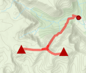
Show map
Route description
1. Getting to Glen Doll

Visitor centre in Glen Doll
Glen Doll is the starting point of this route, with the nearest town being Kirriemuir to the south. From Kirriemuir, roadside signs lead out of the town to Glen Clova.
In Glen Clova the road forms a circular route on either side of the River Clova, where apparently an unofficial clockwise one-way system is in place.
High up Glen Clova, the road crosses a bridge by Glen Clova Inn, from where a single-track road is followed for just under 6km to a large car-park at the road end. It costs £3 to park here - worth the improved visitor facitilies including centre, toilets and path construction.
2. Driesh

Summit plateau of Driesh
From the car-park, follow the track north-west, pass some farm buildings, through a gate and come to a junction  with various signs.
At this junction, turn left (marked 'Kilbo Path') and walk down to a bridge.
with various signs.
At this junction, turn left (marked 'Kilbo Path') and walk down to a bridge.
Beyond the bridge the track veeres right, which is followed for 400m to a sharp turn. Look for a path aiming directly uphill. Follow this path, which crosses another track further on (sign post 'Kilbo Path').
The path climbs up what used to be thick forest, but with recent felling, the views are now more open. Further on, the remaining forest is entered and the Burn of Kilbo  is reached and crossed (with care in spate).
The path exits the forest and climbs up below the crest of Shank of Druimfollow to meet with a cairn just before reaching the bealach  between Driesh and Mayar.
The cairn marks a junction in the path - turn to the left and follow the path as it drops slightly, then climbs initially hugging the edge of the corrie.
The path becomes fainter and travels to the summit of Driesh  with a cairn sheltering its trig point.
3. Mayar

Descending Driesh on way to Mayar
Return to the bealach , hike up directly ahead, following a few old fence posts partically buried in the grass and rocks (watch out for the hidden wire in the ground).
Upon reaching the top of Shank of Druimfollow, turn left (west) then continue on fairly level ground, following fence posts east until a Right-of-Way sign at a sharp corner  on the fence line is reached.
At this point, leave the fence behind and on a very obvious and worn path, continue westwards. The ground rises and becomes more bouldery as the summit of Mayar  is attained.
4. Tom Buidhe

Old fence-post point the way north from Mayar to Tom Buidhe
Leave Mayar and head north-west following a very faint path and some tired, old fence-posts over pathless grassy ground. After just under 1km, the path divides  , with one branch heading north and ther other following the remnants of the fence-line westwards. Follow the fence line and head up the southern shoulder of Dun Hillocks to pick up a stalkers ATV track (at grid ref NO232740)
  .
.
The track can be followed to the summit of Dun Hillocks  , where it turns south-west of aim for Finalty Hill. But instead of following this, leave the track and aim north over fairly featureless grass and peat-hagged ground to hike up Little Kilrannoch
  .
.
More gently undulating grass covered ground leads to Tom Buidhe 1½km further on  . Not much of a cairn, though the views are suprisingly quite good.
5. Tolmount

Tolmount's summit cairn and view to Lochnagar and Broad Cairn
Following a faint worn path, head west for just under ½km. The path splits, take the right fork, to head downhill to cross a small burn in the middle of the bowl ahead.
After crossing the burn, the path seems to disappear - aim uphill directly ahead, then turning north-north-east, you should be able to see a line of iron fence-posts. The line of posts travel between Cairn of Claise and Tom Buidhe.
The line of posts and a faint path alongside it continue over grassy ground northwards in the direction of Tolmount. As Tolmount's summit nears, ground becomes a bit more rocky in places, with the cairn on the top being a rather untidy bouldery pile  . Amazing how close Lochnagar looks from here !
6. Return

Shelter on Jock's Road
Aim east-north-east on a fairly obvious path and some fence posts for just under 1km and pick up 'Jock's Road', the old drover's road linking Glen Callater to Glen Doll.Turn south-east to reach the small cairn on Crow Craggies  .
.
Continue following Jock's Road (rough in bits, but fairly well maintained), past the grassed-over emergency shelter  , down into Glen Doll. Into forestry, the path becomes a track as it returns to the car-park.
Route profile »

Maps and GPX downloads »


|
Download GPX of route |
The map images above link to items on Amazon. A small commission is earned on any map purchased which helps fund the operating costs of this website.
Weather forecasts »
| Regional | MWIS - Southeast Highlands |
| Peak specific | Mountain Forecast.com Met Office YR.no |
| Seasonal | SAIS - Southern Cairngorms Midge forecast |
Alternative and nearby routes »
Driesh and Mayar | |
|
North of Forfar and Kirriemuir, Jock's Road runs along The Angus Glens towards Braemar. Overlooking this old drove road are the Munro twins of Driesh and Mayar, two rolling hills with fine paths that make for an easy afternoon's hillwalk. Peaks : 2 Munros
Ascent : 900m (2950ft) Distance : 14km (9m) Time : 5hr |
Glenshee 9 Munros | |

|
The 9 Munros above Glenshee can be linked to form a long high-level hiking circuit. With generally grass covered slopes, this is one of the easier ways to go multi-Munro-bagging ! Peaks : 9 Munros
Ascent : 1690m (5540ft) Distance : 30km (19m) Time : 10:15hr |
Ben Tirran from Glen Clova | |

|
A circular route above the glacially carved landscapes surrounding Loch Brandy and Loch Wharral leads to 'The Goet', the highest point on Ben Tirran. Peaks : 1 Corbett
Ascent : 870m (2850ft) Distance : 15km (9m) Time : 5:15hr |
Lochnagar and Loch Muick circuit | |

|
A group of five Munros surround Loch Muick in Royal Deeside. Including mighty Lochnagar, these peaks form a terrific high-level hiking circuit. Peaks : 5 Munros, 1 Corbett
Ascent : 1340m (4400ft) Distance : 28km (17m) Time : 9:15hr |


