
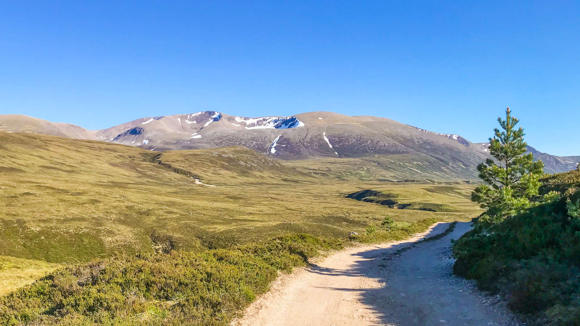
Sgor Gaoith and Braeriach from Loch Einich
Hillwalking route through Glen Einich up Braeriach and Sgor Gaoith
Between forested Glen Feshie and the famed Lairig Ghru is Loch Einich surrounding by high undulating ground with the impressive Munro summits of Braeriach and Sgor Gaoith situated at opposite sides. Possibly one of the best ways to do this route is to back-pack, camping by one of the little lochans on the Moine Mhor plain.
Route outline
| Munros | ||||
| Walk ascent | 1410m (4620ft) | |||
| distance | 19km (12m) | |||
| time | 7:00hr | |||
| Bike ascent | 270m (880ft) | |||
| distance | 23km (14m) | |||
| time | 2:00hr | |||
| Start/finish | Coylumbridge Grid Ref : NH915107 | |||
| Terrain |
| |||
| Nav |
| |||
| Effort |
| |||
| Scenery |
| |||


This route begins from Coylumbridge just outside Aviemore and heads through Caledonian forests of Rothiemurchus on excellent estate tracks. Reaching Loch Einich (Loch Eanaich on newer maps), the landscape dramatically changes with the loch surrounded by high cliffs and buttresses of Sgor Gaoith.
The most well pathed route up heads up through Coire Dhondail (used for the descent of this route) and there is another path on the western bank of Loch Einich. Higher up vast sprawling undulating ground can be tricky to navigate on, particulary away from paths. The rims above cliffs and crags on Braeriach will help with navigation, though in winter beware of the cornices that can form !
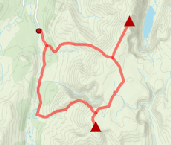
Show map
Route description
1. Getting to Coylumbridge

Sgoran Dubh Mor from the Am Beanaidh
On the south side of Aviemore, there is a roundabout, from where the road to Cairngorm Mountain begins. Around 3km down this road are the houses of Coylumbridge, just before which is the entrance to Rothiemurchus Campsite. There is a roadside layby to park in.
2. Loch Eanaich (Einich)

Metal bridge over the Am Beanaidh, Braeriach ahead
A bike is recommended for the 12km to Loch Eanaich (Loch Einich on older maps). The track is pretty good most the way and a hybrid-bike or gravel-bike should cope with the surface.
Cycle down the track, through the campsite towards Gleann Eanaich, following the signs. After around 3km, you'll come to a crossroads  , to the left is the Cairngorm Club Footbridge and to the right is Loch an Eileen, both worthy of a detour. Keeping straight-on aims to Loch Einich.
A further 2km on, the track splits  , either fork will do - the right fork aims uphill on a fine well maintained track and requires a bit of thigh effort, whereas the left fork keeps low but is more overgrown and looks as if it is no longer maintained by the estate. The tracks merge again, shortly after which a metal bridge
  over the Am Beanaidh is crossed (cyclists will need to dismount for this). Another 1km down and a burn heading down from Braeriach (the Beanaich Bheag) is met - in most conditions this should be easily crossed, but can mean wet feet !
Just before reaching Loch Eanaich, you'll meet up with the path coming down from Braeriach  , probably best to leave bikes here.
3. Sgor Gaoith

Just below the summit of Sgor Gaoith
Head up to Loch Eanaich, cross the outflow from the loch (very difficult in spate) then bound over the grass and heather covered damp ground towards Loch an t-Seilich  . From here, I took a direct route up to Sgoran Dubh Mor
  , which although very steep, was pretty straightforward with only a a couple of sections of easy scrambling. I'm sure there'll be an easier route starting slightly further north !
Sgoran Dubh Mor is a domed summit, covered in grass from where a delightful walk southwards reaches Sgor Gaoith's summit  overlooking crags dropping to Loch Eanaich below.
4. Braeriach

Summit of Braeriach
Navigation beyond Sgor Gaoith will be challenging, particularly in mist. The Moine Mor path and a track coming from Mullach Clach a'Bhlair can help part of the way, but will also add in distance and time.
Leave Sgor Gaoith and head on a bearing just west of south, handrailing the top of Coire Odhar. Reaching the slopes of Carn Ban, begin to turn south-east and start to lose height. Ground is grassy and undulating with small lochans popping up here and there and no paths to follow. Loch nan Cnapan is an excellent spot for wild camping if backpacking this route over two days.
When starting to climb, aim north-east for 3km up onto Carn na Criche with its small cairn  (marked just with a spot height of 1265m on older OS maps).
North-east again, meet up with the crags above Garbh Coire and follow them towards the Wells of Dee  - a wide grass covered area above the Falls of Dee. Terrain now becomes more boulder-covered, but some faint paths can be traced for the last 1km onto the summit of Braeriach
  . This is an exceptional location, the cairn perched above massive drops and cliffs overlooking the Lairig Ghru, giving spectacular views to Ben Macdui and Cairn Toul.
5. Return to Coylumbridge

Descending Coire Dhondail to Loch Einich
You could re-trace your steps back to Carn na Ciche, but for more variation and different views, I'd recommend aiming due west and heading for the cairn  just over 1km away (on spot height 1235). Turn south-west and aim for Einich Cairn
  , then continue downhill, picking up the rim of Coire na Clach. Follow this down and pick up a well-defined path
  travelling down into Coire Dhondail. The path reaches the track just north of Loch Eanaich .
Another alternative is to head for the cairn (on spot height 1235), then head north-west and descend via a burn dropping to Gleann Eanaich around 1½km north of Loch Eanaich. Lower down it's on steep heather-clad ground and pathless.
Return to Coylumbridge on the track, mostly free-wheeling !
Route profile »

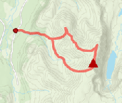
Maps and GPX downloads »


|
Download GPX of route |
|
|
Download GPX of alternative ascent |
The map images above link to items on Amazon. A small commission is earned on any map purchased which helps fund the operating costs of this website.
Weather forecasts »
| Regional | MWIS - Cairngorms and Monadhliath |
| Peak specific | Mountain Forecast.com Met Office YR.no |
| Seasonal | SAIS - Northern Cairngorms Midge forecast |
Alternative and nearby routes »
Sgor Gaoith and Mullach Clach a'Bhlair from Glen Feshie | |
|
Above Glen Feshie, Sgor Gaoith and Mullach Clach a'Bhlair are two Munros that lie in the heart of Rothiemurchus, a vast area of Caledonian forest, lochs, rivers, glens, mountains, and wild landscapes. The high ground, known as the Moine Mhor, is fairly featureless for the most part, but fortunately some good paths and tracks aid navigation. Peaks : 2 Munros
Ascent : 1100m (3610ft) Distance : 26km (16m) Time : 8:20hr |
Sgor Gaoith and minor tops | |
|
The long ridge of Sgor Gaoith and Sgoran Dubh Mor runs north-south between Glen Feshie and Glen Einich. On the Glen Feshie side, these peaks form a soft rolling landscape which contrasts with the impressive cliff and crags on the other side above Loch Einich. Peaks : 1 Munro
Ascent : 1020m (3350ft) Distance : 15km (9m) Time : 5:30hr |
West of Lairig Ghru from Glenmore | |

|
West of the Lairig Ghru, huge cliffs rise to vast plateaux and some of the highest peaks in the land, Braeriach, Cairn Toul and Sgor an Lochain Uaine. Fine paths lead in from Glenmore and Coylumbridge and with the lowest point on the ridges between the Munro summits being above 1100m, the views are quite superb, particularly from Braeriach. Peaks : 3 Munros
Ascent : 1850m (6070ft) Distance : 28km (17m) Time : 10hr |
Leathad an Taobhain from Glen Feshie | |

|
A bike on estate tracks through beautiful Glen Feshie, followed by some thigh-busting uphills gets close to Leathad an Taobhain's summit. Only a hike of just over 1km remains ! Peaks : 1 Corbett
Ascent : 900m (2950ft) Distance : 33km (21m) Time : 4:20hr |


