

Schiehallion from Braes of Foss
Hillwalking route up Schiehallion from Braes of Foss
Schiehallion is one of Scotland's most popular mountains with many a hill-walker having their first Munro-bagging experience hiking up this distinctive peak.
Route outline
| Munros | ||||
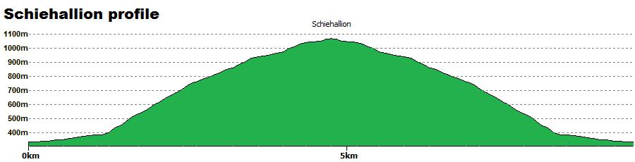
| Ascent | 750m (2460ft) | |||
| Distance | 10km (6m) | |||
| Time | 3:45hr | |||
| Start/finish | Braes of Foss Grid Ref : NN753556 | |||
| Terrain |
| |||
| Nav |
| |||
| Effort |
| |||
| Scenery |
| |||


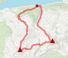
The route most people take is from Braes of Foss through John Muir Trust land, where a well-constructed path lead up Schiehallion's eastern flank. This path rises to around 870m, thereafter care is needed while crossing the reamining 2km of heather and boulderfield towards Schiehallion's summit. On the boulderfield and in mist, the path can easily be lost, so you will need your navigational wits about you !
Show map
Route description
1. Getting to Braes of Foss

The shieling by Schiehallion's path
The fairly narrow roads into the area are best accessed from the A9 at either Ballinuig or just north of Pitlochry.
Just south of the highest point on the Aberfeldy-Tummel Bridge road (B846), a sign points west to 'Schiehallion Road'.
Follow this road for 3km to a car-park by Braes of Foss.
In winter this road doesn't seem to be well-gritted !
2. Schiehallion

On way up Schiehallion with Meall Tairneachan in distance
From the Braes of Foss car-park, head to its southern end and through a gate to a couple of information boards put up by the John Muir Trust. The old wet route, which is slowly being taken back by nature, used to head around the northern side of the forest seen ahead.
The current route heads south around this forest  on a well constructed path. The path starts to turn, meets up with a stone fank
  and crosses an old faint track.
It then starts to climb, passing a few stone 'chairs' that make for a fine picnic spot looking onto Meall Tairneachan and over to Beinn a'Ghlo.
The path twists as it continues to rise and ends abruptly  at around the 870m contour at a fine view looking north.
Now on boulderfield and through heather with a bit of peat-bog, head westwards.
A cairn is seen ahead, this is not the summit. Nor is the next one !
Heather is left behind and now just boulderfield  - requiring concentration and is at odds with the path left behind.

On Schiehallion's summit
 is reached with its vast and outstanding views. I've been up this hill som many times, and each time that I have reached the summit on clear days, I am still stunned by the beauty of the area.
On Schiehallion's summit
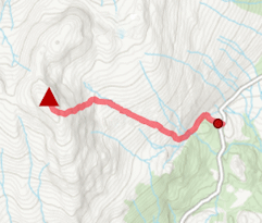
3. Return to Braes of Foss

Leaving Schiehallion's summit in winter
The easiest way back is to return by the same route.
Route profile »
Maps and GPX downloads »

|
Download GPX of route |
The map images above link to items on Amazon. A small commission is earned on any map purchased which helps fund the operating costs of this website.
Weather forecasts »
| Regional | MWIS - Southeast Highlands |
| Peak specific | Mountain Forecast.com Met Office YR.no |
| Seasonal | SAIS - Glencoe Midge forecast |
Alternative and nearby routes »
Meall Tairneachan and Farragon Hill | |
|
Overgrown trails following old walks make for an interesting approach from Loch Tummel towards the Corbett pair of Meall Tairneachan and Farragon Hill. Peaks : 2 Corbetts
Ascent : 1100m (3610ft) Distance : 17km (11m) Time : 6:10hr |
Beinn a' Chuallaich from the B847 | |
|
Farmland and forestry tracks rapidly give way to a plod through deep heather for a direct route up Beinn a' Chuallaich. Peaks : 1 Corbett
Ascent : 620m (2030ft) Distance : 6km (4m) Time : 2:30hr |


