
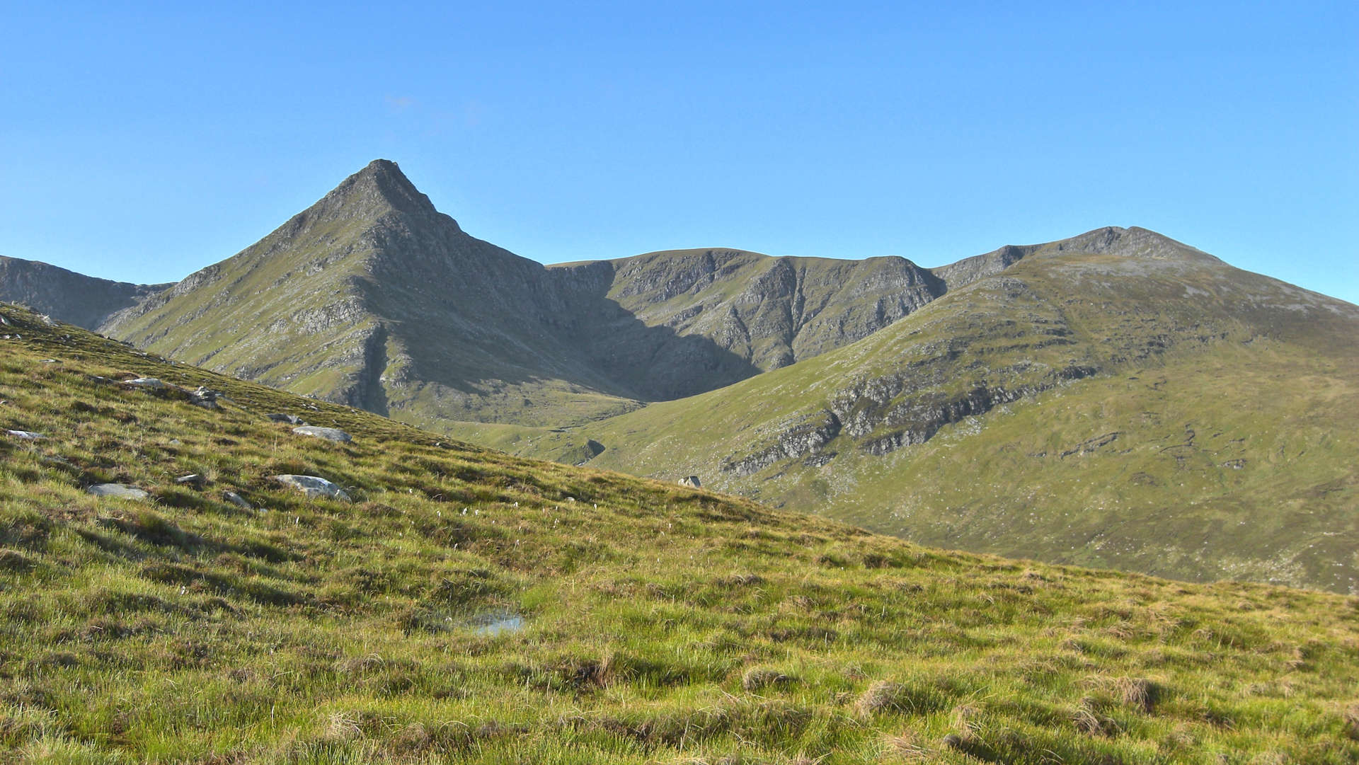
Seana Bhraigh from Corriemulzie
Hillwalking route up Seana Bhraigh from Oykel Bridge
Drive down a forestry track, cycle along a quiet glen and hike up grass and heather clad slopes - this is the easiest route up Seana Bhraigh !
Route outline
| Munros | ||||
| Walk ascent | 700m (2290ft) | |||
| distance | 9km (6m) | |||
| time | 3:15hr | |||
| Bike ascent | 230m (750ft) | |||
| distance | 18km (11m) | |||
| time | 1:15hr | |||
| Start/finish | Oykel Bridge Grid Ref : NH340975 | |||
| Terrain |
| |||
| Nav |
| |||
| Effort |
| |||
| Scenery |
| |||


Seana Bhraigh is one of the more remote Munros, tucked away behind other hills in the North West Highlands. Fortunately there are many glens leading to the base of the mountain along which a fine network of estate tracks and paths follow.
Possibly the easiest, but not the shortest route, heads in from Oykel Bridge to the north-east of Seana Bhraigh. This route travels along rough estate tracks up Glen Einig and Strath Mulzie to the base of the northern shoulder of the mountain, from where ATV tracks can be traced up to a height of over 600m. This leaves a predominantly grassy ascent of just 300m to Seana Bhraigh's summit, from where superb views can be savoured in all directions. The view over Luchd Choire to Creag an Duine is simply stunning !
Show map
Route description
1. Getting to Oykel Bridge
In Sutherland, the A837 travels from Bonar Bridge at the head of the Dornoch Firth to Lochinver on the North West coast. On this road, around 30km west of Bonar Bridge, sits Oykel Bridge where there is a hotel and a few houses.
2. Old Schoolhouse in Glen Einig

The Schoolhouse in Glen Einig
From Okyel Bridge a narrow road heads south following the west bank of the River Oykel. The road comes to a line of 6 houses, beyond which there is a turning circle  .
.
Beyond the turning circle there is an estate track heading south-west and this can be driven along. However, the track can be rough in places with wet potholes, so if you are fond of your vehicle and it has low ground clearance, it would be advisable instead to head in by foot or on bike.
Follow the track as it turns south over the River Einig  , then takes a sharp turn right. Continue onwards for around 3km, the track takes a sharp turn, crosses a burn
  , then comes to a junction - keep straight on and continue for another 3km.
The track comes to the end of the forest by a cattle-grid  - I parked here last time to keep out of wind. Around 1km further on is the end of the road for hillwalker's vehicles where there is a car-parking area
  by The Schoolhouse and Duag Bridge.
3. Allt a' Choire Bhuidhe

Shoogly bridge over the Allt a' Choire Bhuidhe
Cross Duag Bridge, shortly after which is a junction - keep left on the main track (turning right leads to Loch an Daimh and eventually Ullapool). Follow the track for 3km through woodland to Corriemulzie Lodge  . The track comes to an abrupt end at a gate just past the lodge. Seana Bhraigh and Creag an Duine can be seen ahead in the distance.
Through the gate, the track becomes quite rough as it climbs briefly then drops to the northern bank of Corriemulzie River. Follow it for around 3km encountering various minor burn crossings to come to a junction  , keep to the left (the track to the right travels to Glen Doucharyaround the western side of Sean Bhraigh). A further 1 km onward the track comes to the Allt a' Choire Bhuidhe
  - the most significant water crossing on the route.
4. Seana Bhraigh

On Seana Bhraigh's summit looking to Coigach
The track fords the river, which should be easy to cross in fair conditions. In spate this will be tricky, if impossible to cross, in which case head upstream for a few metres where there is a wooden bridge (on my last visit this bridge was near to collapse).
Once over, continue along the track for around 500m to meet up with a cairn  shortly before the track crosses Corriemulzie River. This cairn marks the start of rougher track heading south-west - follow this for another 500m or so to yet another small cairn
  which marks the start of ATV tracks heading southwards uphill away from the track (the track heading south-east comes to a dead-end).
The ATV tracks climb gently at first, then turn and head uphill towards the spur of Meallan Odhar. Passing a few flag-stones on the way, the tracks end by a tiny cairn on the summit of this minor hump  .
.
From this summit turn left 90o and aim directly uphill south-east over heather and some short sections of boulderfield. You'll come to a small lochan  on Seana Bhraigh's north-east shoulder, behind which a faint but obvious path leads south-west up the crest.
The path traces a route on the crest as it rises and turns around the top of Luchd Choire.Higher up, the gradient easies and the summit of Seana Bhraigh  is reached where a small wall of stones encircles the remains of a trig-point base. Superb views in all directions !
5. Return

From Seana Bhraigh to Creag an Duine
The easiest route for return is to simply re-trace your steps back down into Strath Mulzie.
An alternative begins with a return to the lochan on Seana Bhraigh's north-east ridge. Beyond this continue tracing the faint path down the ridge to the mouth of Loch a' Choire Mhor  . The river flowing out will need crossing, from where a track heads northwards to return.
Another option would be a visit to Creag an Duine. This takes in a relaxed walk over the wide expanse of Seana Bhraigh's plateau and its minor summit  marked '906m' or '905m' depending on which map you use. This is followed by a fairly exposed, but technically easy scramble up loose ground to Creag an Duine's summit, An Sgurr . I suspect descending down the north ridge from here to Loch a' Choire Mhoir would be significantly harder than heading up in reverse ! (This route is descibed in the SMC Munros guidebook - personally I've been up Creag an Duine from the south, but not on the north ridge !)
Route profile »

Maps and GPX downloads »


|
Download GPX of route |
The map images above link to items on Amazon. A small commission is earned on any map purchased which helps fund the operating costs of this website.
Weather forecasts »
| Regional | MWIS - Northwest Highlands |
| Peak specific | Mountain Forecast.com Met Office YR.no |
| Seasonal | SAIS - Torridon Midge forecast |
Alternative and nearby routes »
Inverlael Munros | |

|
South-east of Ullapool, a network of forestry tracks and old stalkers paths reach into the vast areas of Inverlael, Freevater and Strath Vaich Forests where Beinn Dearg's bouldery, grey dome rises high above neighbouring Munros. Peaks : 6 Munros
Ascent : 2600m (8530ft) Distance : 35km (22m) Time : 13hr |
Beinn Enaiglair from Braemore | |

|
On the edge of Inverlael, estate tracks lead to the base of Beinn Enaiglair, from where a pathless circular route travels over heather and grass covered slopes to arrive at fine viewpoints. Peaks : 1 Corbett
Ascent : 740m (2430ft) Distance : 12km (7m) Time : 4:15hr |
Carn Chuinneag from Glen Calvie | |

|
A delightful walk (or cycle) though the woodlands of Glen Calvie leads to the base of Carn Chuinneag, from where a stalkers track climbs to the twin summits of this distinctive Corbett. Peaks : 1 Corbett
Ascent : 780m (2560ft) Distance : 16km (10m) Time : 5:20hr |
Breabag and the Bone Caves | |

|
A hike of two halfs - fine paths on lower ground to the 'bone caves', followed by pathless grass and heather covered terrain to Breabag's summit crest. Peaks : 1 Corbett
Ascent : 700m (2300ft) Distance : 10km (6m) Time : 3:40hr |


