
Gairich and Sgurr Mor from Glen Kingie
Hiking and biking route along Glen Kingie and up Gairich, Sgurr an Fhuarain and Sgurr Mor
South of Loch Quoich, fine forestry and estate tracks enable the use of a bike to travel along Glen Kingie, from where a delightful route following paths and ridges reaches the summits of Gairich, Sgurr an Fhuarain and Sgurr Mor.
Route outline
| Munros | ||||
| Corbetts | ||||
| Walk ascent | 1665m (5460ft) | |||
| distance | 17km (11m) | |||
| time | 7:00hr | |||
| Bike ascent | 580m (1900ft) | |||
| distance | 32km (20m) | |||
| time | 2:05hr | |||
| Start/finish | Poulary Grid Ref : NN132015 | |||
| Terrain |
| |||
| Nav |
| |||
| Effort |
| |||
| Scenery |
| |||


Estate and forestry tracks travel up the length of Glen Kingie, on which a bike can be used to reach the heart of a wilderness on the edge of the Rough Bounds of Knoydart. From here a delightful hillwalking route following old stalkers paths up crests and ridges reaches the summits of Gairich, Sgurr an Fhuarain and Sgurr Mor.
Show map
Route description
1. Getting to Poulary

River Garry by Poulary
The A87 travels from Invergarry in the Great Glen westwards through Kintail and onwards to Skye. On this road, around 8km west of Invergarry and above the shores of Loch Garry, there is a junction with an unclassified road which is marked heading to Tomdoun and Kinlochourn (sic).
Follow the unclassified road above the shores of Loch Garry and into the forests surrounding Tomdoun. Past the forests, the road passes a recently renovated old white house on your right. Beyond this, there are a few houses on your left in sparse woodland, all with access roads - the third of these has a right-of-way sign - this is the beginning of the route to Glen Kingie.
Parking is very limited nearby !
2. Bike along Glen Kingie

Heading along the forests in Glen Kingie
From the roadside, head down the access road, through a gate and keep left on the main track downhill to the bridge over River Poulary  .
.
Over the bridge, the track heads into forestry (much felled and recently re-planted) and aims west for 500m before turning south for 1km. Coming to a junction in the track, keep right (turning left leads uphill to the foot of the Corbetts above the eastern end of Loch Arkaig), before turning west again for a further 4km.
A bridge over River Kingie  is crossed beyond which the track becomes a tad rougher and less used.
A further 3km on, the track comes to a junction  . Turn left and head down to the ruin of Lochan
  with much of the dense forestry now left behind.

Ruin of Lochan
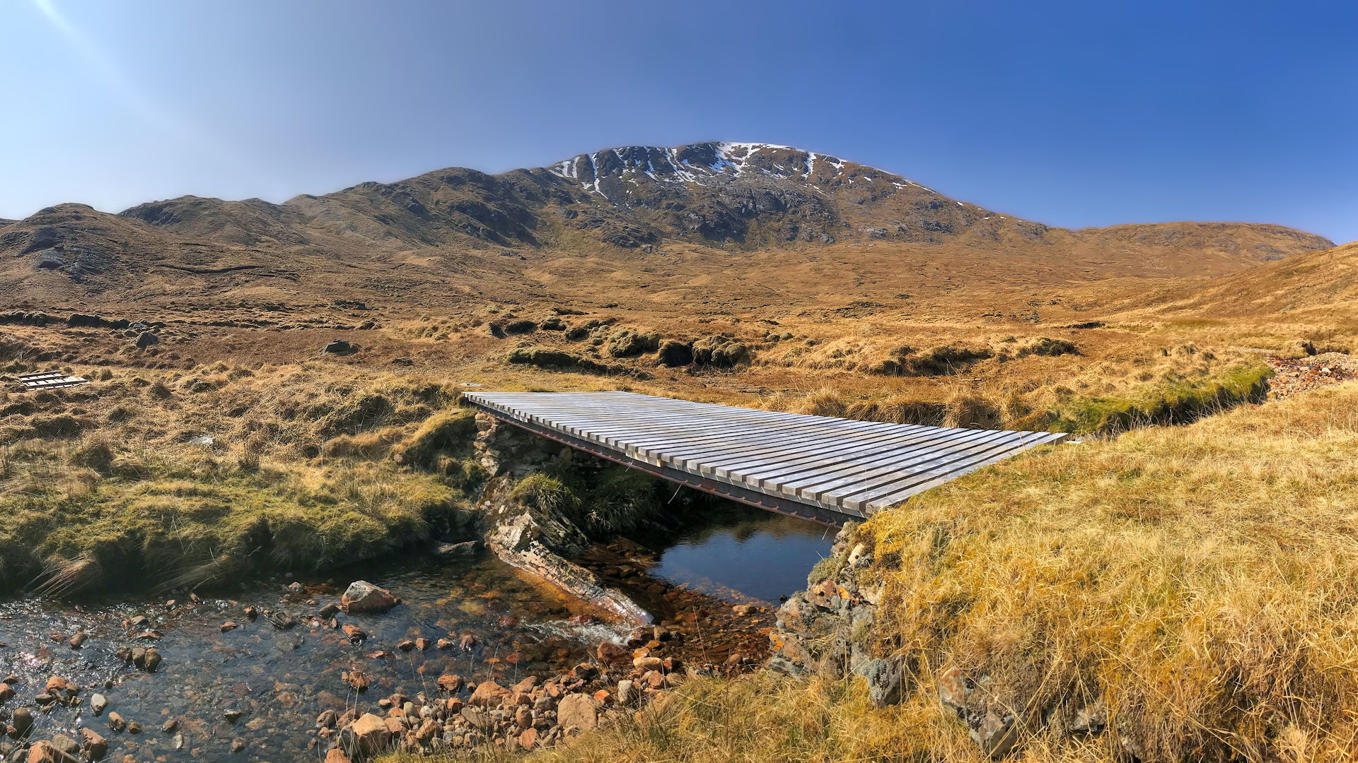
 , marked by a fence-line, is reached and the track becomes significantly rougher, though still cycleable. On bike, all that remains is cycle up a gentle incline over the next 3km to arrive at a wooden bridge over the Allt a' Choire Ghlais
  .
.Ruin of Lochan
3. Gairich

Gairich from Gairich Beag
After leaving your bike by the bridge, don't cross the bridge, instead hike uphill on the track that travels north-west towards Clach na Meineir - the bealach between Gairich Beag and Sgurr an Fhuarain. On nearing the highest point of this track, you'll come to the base of a stalkers path  heading east, uphill.
The track is well defined, though occasionally soggy and twists and turns as it climbs 300m up the western side of Gairich Beag. Ascent easies and the path disappears into grass while approaching the flat moorland of Gairich Beag  .
.

On Gairich's summit looking west
 .
.On Gairich's summit looking west
4. Sgurr an Fhuarain

Stalkers path below Gairich Beag, Sgurr an Fhuarain ahead
Leave Gairich's summit behind and return to the track on Clach na Meineir . Cross this track and the accompanying line of old fence-posts and hike over the soggy ground of Clach na Meineir to pick up and follow the faint remains of another stalkers path heading southwards.
The old stalker's path gradually disappears into grass, from where strike up steep grassy ground up onto the eastern arm  of Sgurr an Fhuarain.
Pathless grass covered ground is ascended aside occasional old irons fence-posts. The crest of the hill widens and the fence-posts are left behind to instead aim directly uphill for the remaining 150m ascent to Sgurr an Fhuarain's summit  with its conical trig point and small cairn.

On Sgurr Fhuarain, looking to Sgurr Mor
On Sgurr Fhuarain, looking to Sgurr Mor
5. Sgurr Mor

At the bealach below Sgurr Mor
At just over 2km away, Sgurr Mor appears surprisingly close when viewed from Sgurr an Fhuarain's summit.
Head west from Sgurr an Fhuarain's summit along a faint path over pleasant grass covered ground on its western shoulder. While taking in the views ahead, a height of 200m is lost descending the shoulder's gentle slope over a distance of just over 1km to reach the bealach  between Sgurr an Fhuarain and Sgurr Mor.
From the bealach, start heading up Sgurr Mor east facing grassy slope, the path now more obvious . As the route turns north-west, the path narrows and zig-zags a bit as terrain becomes a tad rougher than that of the descent of Sgurr an Fhuarain.
Further up and after climbing around 200m, the path turns westwards for the final climb up rockier ground onto Sgurr Mor's summit crest. The faint path crosses undulating ground to reach Sgurr Mor's summit  , where a cairn made up of a large untidy pile of stones and boulders stands and provides just enough shelter out of any wind.

Approaching Sgurr Mor's summit from the east
Approaching Sgurr Mor's summit from the east
6. Return

On Sgurr an Fhuarain's summit looking to Gairich
Retrace your steps back down to the bealach between Sgurr Mor and Sgurr an Fhuarain. Decision - direct downhill to Glen Kingie for a hike along a path to your bike, or up and over Sgurr an Fhuarain to your bike ?
If weather isn't great, I'd go for the direct descent to Glen Kingie - it's a fairly steep drop of 500m on grass making for an enjoyable downhill run. The path in Glen Kingie is pretty good.
If weather is fine, I'd opt to stay high. The effort of the ascent back up to Sgurr an Fhuarain's summit is rewarded by the having mountain views for longer. This route is also slightly shorter !
Route profile »

Maps and GPX downloads »


|
Download GPX of route |
Information on maps and GPX files is on this page.
The map images above link to items on Amazon. A small commission is earned on any map purchased which helps fund the operating costs of this website.
Weather forecasts »
| Regional | MWIS - Northwest Highlands |
| Peak specific | Mountain Forecast.com Met Office YR.no |
| Seasonal | SAIS - Lochaber Midge forecast |
Alternative and nearby routes »
Rough Bounds from Loch Quoich | |

|
From Loch Quoich Dam, a hike up Gairich is followed by a challenging route following well defined paths and stalkers tracks along crests to Sgurr na Ciche, the highest peak in the Rough Bounds of Knoydart. Peaks : 5 Munros, 1 Corbett
Ascent : 3240m (10630ft) Distance : 39km (24m) Time : 15:5hr |
Glen Dessarry Munros | |

|
A cycle along Glen Dessarry leads to a gully scramble and a traverse following old walls on the fine ridge from Sgurr na Ciche over Garbh Chioch Mor to Sgurr nan Coireachan. Peaks : 3 Munros
Ascent : 1510m (4950ft) Distance : 29km (18m) Time : 7hr |
Loch Arkaig Corbetts | |

|
From the western end of Loch Arkaig, a route following grass-covered crests, old walls and fence-lines, takes in 3 Corbett peaks of Sgurr Cos na Breachd-laoidh, Fraoch Bheinn and Sgurr Mhurlagain on the edge of the Rough Bounds of Knoydart. Peaks : 3 Corbetts
Ascent : 1900m (6230ft) Distance : 20km (12m) Time : 8:10hr |
Meall na h-Eilde and Geal Charn | |

|
Starting from the shores of Loch Arkaig, this route forms a delightful circuit over grass covered crests following fence-lines while bagging the Corbetts of Meall na h-Eilde and Geal Charn and Grahams of Glas Bheinn and Sgurr Choinnich. Peaks : 2 Corbetts and 2 Grahams
Ascent : 1700m (5580ft) Distance : 22km (14m) Time : 8:20hr |


