
Ben Wyvis from Garbat
Hillwalking route from the forests of Strathgarve to Ben Wyvis's summit Glas Leathad Mòr, extendable over other Munro Tops and Little Wyvis.
Route outline
| Munros | ||||
| Corbetts | ||||
| Ascent | 910m (2980ft) | |||
| Distance | 14km (9m) | |||
| Time | 4:35hr | |||
| Start/finish | Garbat Grid Ref : NH409671 | |||
| Terrain |
| |||
| Nav |
| |||
| Effort |
| |||
| Scenery |
| |||


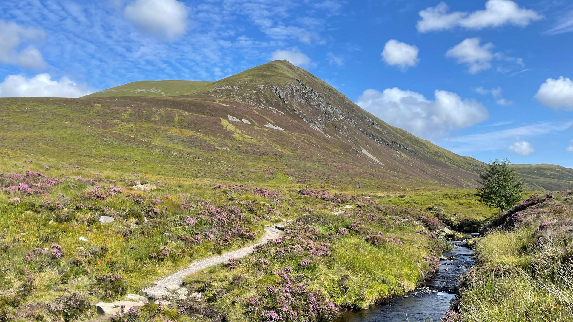
Ben Wyvis, often referred to as Inverness's 'Ben' is a popular hill. The Forestry Commission and Scottish Natural Heritage own much of the ground and have improved the access to Ben Wyvis and enlarged the car-park. From what was once a wet peat path that winded up through the heather, there is now a wonderful well constructed path up the slopes of An Cabar.
But don't be led into a false sense of security by the obviousness of the path - the featureless whale-back summit plateau of Ben Wyvis can catch out even the most experienced hillwalker when their guard and the mist are down.
Show map
Route description
1. Getting to Garbat

Route up Ben Wyvis from Garbat
North of Inverness, the A835 travels from Tore on the A9 to Ullapool. On this road, around 6km north of Garve and just south of the bridge over the Allt Bhealaich Mhoir, there is the Ben Wyvis car-park with its information board and has room for around 20 vehicles.
There is a height restricting barrier at the entrance to the car-park, therefore high vehicles will need to park just along the road in one of the lay-bys. Beware, in summer and autumn the midges here can be savage !
2. An Cabar and Glas Leathad Mòr on Ben Wyvis

Erratic boulder at top of constructed path
The path from the car-park travels northwards parallel to the road for a short distance to a footbridge over the Allt a'Bhealaich Mhòir.
Cross the bridge, then turn right, head through a gate and start to climb on a well constructed path uphill following the course of the Allt a'Bhealaich Mhòir.
Progress is easy up this, crossing a forestry track  on the way after which views open up with much of the surrounding forest having been felled.
After around 2km, the track starts to level, the Forestry Commission land is exited  and Nature Scot managed land is entered.
The contructed path continues eastwards a bit further, then turns northwards, before twisting and turning uphill.
After a series of steps, the constructed path ends by an erratic boulder and a boot-worn path continues climbing, travelling towards the summit of An Cabar  , where two small cairns sit, the second on this top's summit.
(An Cabar can be bypassed - when approaching this minor summit and reaching the 900m contour, a small cairn marks the start of a faint path which can be traced heading north-east. This travels just below the crest of Ben Wyvis for around 1km and around the bump of Càrn a' Chaiptein).
Leave An Cabar's cairns and head north-east on a well-worn path as it progresses along the wide crest of Ben Wyvis.
A gradual climb up and over Càrn a' Chaiptein (cairn at spot height 980m), not long after which a sporadic line of old iron fence-posts can be seen and followed all the way to Glas Leathad Mòr  , Ben Wyvis's summit.

Ben Wyvis summit with Càrn Chuinneag beyond
Ben Wyvis summit with Càrn Chuinneag beyond
3. Alternative ascent via Little Wyvis

Ben Wyvis from Little Wyvis
Having followed the above route to the edge of the Forestry Commision land , cross the Allt a'Bhealaich Mor, which can usually just be jumped, then head south up thick grass and heather (pathless).
Reach the head of a track  at around c630m, and cross it. A faint trod can be traced up to the bealach between Tom na Caillich and Little Wyvis, from where ruts of ATVs and some fence-posts travel to the summit of Little Wyvis
  .
.
To continue to Ben Wyvis, firstly return to the bealach, then turn and head east over easy ground to Little Wyvis's north-east minor top, Tom na Caillich  .
From here, keep roughly east - the crags marked on the map are easily avoided - then descend to the damp ground at the foot of An Cabar.
.
From here, keep roughly east - the crags marked on the map are easily avoided - then descend to the damp ground at the foot of An Cabar.
Head directly up to An Cabar, then up to Ben Wyvis's trig point on Glas Leathad Mòr as described above.
4. Return and detour to Ben Wyvis's 'tops'

Glas Leathad Mòr and Tom a' Coinnich from Glas Leathad Beag
The easiest return route is to simply about-turn and re-trace your steps back to An Cabar, then back down to Garbat.
Simply bagging Ben Wyvis's summit Glas Leathad Mòr doesn't take much effort on a fine day, so an enjoyable option is extend the route by staying up high and bagging the mountain's northern tops.
To do this, from the trig point on Glas Leathad Mor, head north-north-east downhill on a path over the wide expanse of Ben Wyvis's crest to Bealach Tom a' Chòinnich  .
On the other side of the col, climb 50m up to the 900 contour, then continue north-north-east, bypassing Tom a'Chòinnich and onto its north-eastern shoulder.
Follow this wide ridge north-east to a col
.
On the other side of the col, climb 50m up to the 900 contour, then continue north-north-east, bypassing Tom a'Chòinnich and onto its north-eastern shoulder.
Follow this wide ridge north-east to a col  , then east as the ground gets slightly bouldery as the rate of ascent increases.
Climb up to a rise at c910m  , then head over pleasant terrain to Glas Leathad Beag
  at 928m. If you want an even better view over Loch Glas, head a bit further to Meall nan Bradan Leathan.

Heading to Tom a'Chòinnich from the east
 .
From the small cairn on this summit, turn right (north-west) and head down a path zig-zagging through some scree to Càrn Gorm
.
From the small cairn on this summit, turn right (north-west) and head down a path zig-zagging through some scree to Càrn Gorm  .
Now following a wall and on very bouldery ground, turn south-east to drop to heather, then to pick up a faint path following a burn into the forest.
Pick up the forestry tracks
.
Now following a wall and on very bouldery ground, turn south-east to drop to heather, then to pick up a faint path following a burn into the forest.
Pick up the forestry tracks  to follow to the Allt na Bana-mhorair
  and down to the A835 near Garbat Farm, from where its a short roadside walk back to the car-park.
Heading to Tom a'Chòinnich from the east
Route profile »

Maps and GPX downloads »


|
Download GPX of route |

|
Open route in OS Maps |
The map images above link to items on Amazon. A small commission is earned on any map purchased which helps fund the operating costs of this website.
Weather forecasts »
| Regional | MWIS - Northwest Highlands |
| Peak specific | Mountain Forecast.com Met Office YR.no |
| Seasonal | SAIS - Torridon Midge forecast |
Alternative and nearby routes »
Little Wyvis from Silverbridge - easy hillwalk route | |

|
Follow estate tracks from Silverbridge near Garve through forest and farmland for a straightforward ascent of Little Wyvis. Peaks : 1 Corbett
Ascent : 700m (2300ft) Distance : 12km (7m) Time : 3:10hr |
Beinn nan Eun & Càrn Loch nan Amhaichean Route Guide | |

|
Cycle and hike to the Grahams Beinn nan Eun and Càrn Loch nan Amhaichean from Glen Glass. A remote route with panoramic Highland views. Peaks : 2 Grahams/Fionas
Ascent : 1040m (3410ft) Distance : 39km (24m) Time : 6hr |
Meall Mòr from Glen Glass hillwalk route | |

|
Hike Meall Mòr from Glen Glass through old estate tracks and open moorland for superb views over the forested lands and Northern Highlands. Peaks : 1 Fiona/Graham
Ascent : 650m (2130ft) Distance : 15km (9m) Time : 4:50hr |
Càrn Chuinneag from Glen Calvie – hillwalk & cycle | |

|
Cycle or walk through Glen Calvie’s woodland then climb Càrn Chuinneag's twin summits via stalkers path on this remote Corbett route. Peaks : 1 Corbett
Ascent : 780m (2560ft) Distance : 16km (10m) Time : 5:20hr |
Beinn Tharsuinn from Strath Rusdale hillwalk | |

|
Hillwalking route up Beinn Tharsuinn from Strath Rusdale. Quick ascent via estate track leads to wide summit ridge with quiet traverse and fine views. Peaks : 1 Fiona/Graham
Ascent : 560m (1840ft) Distance : 12km (7m) Time : 4hr |


