
Cairngorm Darkside from the north
Route up Ben Macdui and Beinn Mheadhoin from Cairn Gorm ski centre, visiting Loch Avon’s beaches and the famous Shelter Stone en route.
Route outline
| Munros | ||||
| Ascent | 1730m (5670ft) | |||
| Distance | 27km (17m) | |||
| Time | 9:40hr | |||
| Start/finish | Cairngorm Mountain car-park Grid Ref : NH990059 | |||
| Terrain |
| |||
| Nav |
| |||
| Effort |
| |||
| Scenery |
| |||


The Munros on this route are all quite distinctly different. The dome of Cairngorm rests above the ski-centre and crags of the Northern Corries contrasting with the hulk of Ben Macdui, whereas Derry Cairngorm is boulder and scree covered and Beinn Mheadhoin is decorated with weird unusual granite summit tors (the 'Barns of Beinn Mheadhoin').
Unlike the route from the south to bag these Munros where fine estate tracks encourage use of a bike, this approach from Cairngorm ski centre is much rougher and all on foot. However, discovering hidden Loch Avon, investigating the nearby 'Shelter Stone' and getting up close to the crags and landslips below Càrn Etchachan make for a more interesting and challenging route. If backpacking over a couple of days, the grass covered ground surrounding Loch Etchachan makes for an excellent camping spot, or there's the bothy of Hutchieson Memorial Hut just down from the loch.
Much of the high ground above 1000m is of vast plateaux, difficult to navigate on when visibility is reduced by rain, mist or snow.
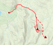
Show map
Route description
1. Getting to Cairngorm Mountain car-park

Cairngorm from the Day Lodge
On the south side of Aviemore, there is a roundabout, from where the road to Glenmore and Cairngorm Mountain begins. It's a journey of around 15km passing lovely Loch Morlich on the way.
There is a frequent bus service from Aviemore direct to Cairngorm Day Lodge.
To park in the Cairngorm Day Lodge car-park costs from £3 outwith the winter snowsports season.
During the winter snowsports season parking is free, however it may be very busy or even full, in which case parking in the lower Coire Ciste car-park is recommended - from where an approach to Cairngorm can be made via Cnap Coire na Spreidhe.
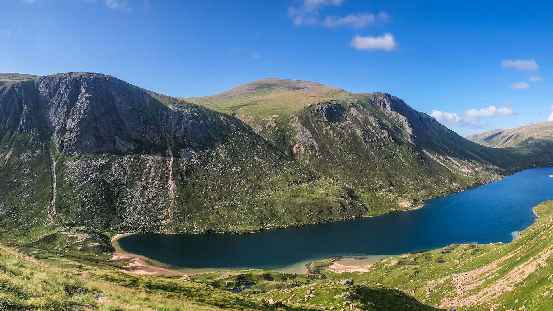
2. Corrie Raibert and Loch Avon

Point 1141 and view to Stob Coire an t-Sneachda
Leave the car-park and head up to the buildings of the ski centre. To the right of the Day Lodge, take a path dropping to a burn, cross this, then turn left on a path running uphill parallel to the funicular railway. After around 1km, the path meets up with the wide Zig-Zags ski piste, which twists a couple of times as it climbs gently uphill. At the second twist, look for a path off-right  (usually marked with a small post). This path, well-constructed in sections, climbs away from the ski-area onto Fiacaill a'Choire Chais and onto the minor summit marked 1141m
  (affectionately known as 'Point 1141').
You may want to head up Cairngorm  on the way to Coire Raibert. If this is the case, rather than doing a detour from 'pt 1141', you could take the 'Windy Ridge' path up Cairngorm (see the Cairngorm and Ben Macdui route page for more info).
Beyond 'pt 1141', drop initially on stoney ground southwards towards Coire Raibert. The ground underfoot becomes grass-covered and a well-constructed path travels down into the coire, keeping to the east bank of the Allt Coire Raibert.

Beinn Mheadhoin from Coire Raibert
Beinn Mheadhoin from Coire Raibert
3. Beinn Mheadhoin

On the path above Loch Avon, Càrn Etchachan and Shelter Stone Crag ahead
The path then climbs over some heathery ground to reach the Feith Buidhe  , the main burn heading into Loch Avon, which will need crossing (and may need boots off to keep dry feet !). The path now climbs to an area with large fallen boulders, in which you should be able to find the 'Shelter Stone'
  , a place to hide out of the wind or camp (I'll stick to my tent thank you !).
Leaving the 'Shelter Stone' behind, follow the worn path south-eastwards uphill. As it levels out and meets up with some pools  , leave the path and cross the Allt nan Stacan Dubha. Aim directly east over heathery ground (there's no path to follow). Fairly quickly, the heather gives way to grass and an easy ascent is made up slopes to Beinn Mheadhoin's westerly tor
  .
.

On Beinn Mheadhoin, looking to Ben Macdui
 , passing some more tors on the way. There are severral tors spread across Beinn Mheadhoin's wide summit plateau, collectively referred to as the 'Barns of Beinn Mheadhoin'. There's no mistaking when Beinn Mheadhoin's summit is reached - two huge granite tors are separated by a narrow gap into which winds funnel through. To reach the top of Beinn Mheadhoin's huge summit tor, head around to its northern side and enjoy a bit of easy scrambling up rough granite.
On Beinn Mheadhoin, looking to Ben Macdui
4. Derry Cairngorm and Ben Macdui

Ben Macdui from Beinn Mheadhoin
Leave the Beinn Mheadhoin's summit tor and return to the westerly tor , from where a faint path can be traced heading south-west along the mountain's plateau. The path drops down to Loch Etchachan  , twisting a route on loose gravelly ground on the way. Cross the outflow of Loch Etchachan and hike up a worn path to just west of Creagan a'Choire Etchachan and below a grassy bealach .
If you fancy a detour to Derry Cairngorm, then turn south away from the path and climb uphill on grassy ground to reach the top of the bealach, from where contour around Creagan a'Choire Etchachan. A path gradually forms heading south and drops to bealach below Derry Cairngorm. The path starts up the north-west shoulder of Derry Cairngorm and quickly disappears into boulderfield making the ascent a bit of a slog. At last Derry Cairngorm's summit  is reached. Return to the grassy bealach
  .
.

On Ben Macdui's summit, looking south
 has a large cairn, ontop of which is a trig pillar and to the side is a viewfinder. Because Ben Macdui has such a large and broad summit, you might have to walk a slight distance from the top to grab the best views, particularly for Cairn Toul and Braeriach.
On Ben Macdui's summit, looking south
5. Return

Cairns marking the return from Ben Macdui towards Cairn Lochan
From Ben Macdui's summit head slightly east of north and drop over bouldery ground. You should find a path heading northwards - to aid navigation there are a line of cairns to follow. As the gradient easies and Lochan Buidhe  is approached, terrain underfoot becomes less bouldery. Just before reaching this lochan, a small cairn marks a split in the path. Take the left fork and gradually the path turns north-west and begins to climb. It levels out, contours around the mass of Cairn Lochan and then drops to a wide flat area
  at the source of the burns heading down into Coire an Lochain. The path now much more obvious and well-constructed, heads down the spur above the west side of Coire an Lochain to cross the Allt Coire an t-Sneachda
  and travel back to the ski centre.

By the Allt Coire an t-Sneachda, Meall a' Bhuachaille ahead
By the Allt Coire an t-Sneachda, Meall a' Bhuachaille ahead
Route profile »

Maps and GPX downloads »


|
Download GPX of route |

|
Open route in OS Maps |
The map images above link to items on Amazon. A small commission is earned on any map purchased which helps fund the operating costs of this website.
Weather forecasts »
| Regional | MWIS - Cairngorms and Monadhliath |
| Peak specific | Mountain Forecast.com Met Office YR.no |
| Seasonal | SAIS - Northern Cairngorms Midge forecast |
Alternative and nearby routes »
Cairngorm 4000s | |

|
Circular hillwalking route over the Cairngorm 4000ers from Glenmore, including Ben Macdui, Braeriach, Cairn Toul, Sgòr an Lochain Uaine and Cairn Gorm. Peaks : 5 Munros
Ascent : 2250m (7380ft) Distance : 28km (17m) Time : 10:45hr |
West of Làirig Ghrù from Glenmore | |

|
Hillwalking route up Braeriach, Cairn Toul and Sgòr an Lochain Uaine, vast high plateaux west of the Làirig Ghru with superb views over the Cairngorms. Peaks : 3 Munros
Ascent : 1850m (6070ft) Distance : 28km (17m) Time : 10hr |
Cairngorm darkside from Linn of Dee | |

|
Route up Ben Macdui and neighbouring Munros from Linn of Dee. Vast plateaux, granite tors, forests and the chance to spot reindeer herds. Peaks : 4 Munros
Ascent : 1850m (6070ft) Distance : 35km (22m) Time : 10:15hr |
Cairngorm and Ben Macdui | |

|
Hillwalking route up Ben Macdui and Cairn Gorm with an optional relatively easy scramble on Fiacaill Ridge in good summer conditions. Peaks : 2 Munros
Ascent : 1000m (3280ft) Distance : 17km (11m) Time : 6hr |
Bynack More and Creag Mhòr from Glenmore | |
|
Hillwalking route from Glenmore up Bynack Mòr and Creag Mhòr. A bike helps access these hills, where weird granite tors crown the summits. Peaks : 1 Munro, 1 Corbett
Ascent : 860m (2820ft) Distance : 22km (14m) Time : 5:30hr |


